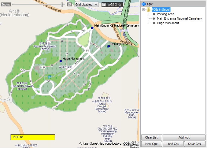
 To start a new GPX-file, use the "New GPX" button (1). A new node will appear in the
list on the panel on the right hand side. Now you can easily add waypoints by using
the "Add wpt" button (2) and continue by clicking on the desired location in the map
preview. The software will ask for a name of that waypoint and will add it to the list. If
you want to delete or rename any items you can do it by performing a mouse right
click on the specific item.
To save your GPX-file use the "Save GPX" button (3). The generated file can be used
along with the offline atlas on most of the handhelds or smartphone applications.
Further the program is able to load GPX files (4) and display their data in the map
preview. You can use this to open files created by MOBAC as well as from other
sources (e.g. recordings from your GPS-handheld).
To start a new GPX-file, use the "New GPX" button (1). A new node will appear in the
list on the panel on the right hand side. Now you can easily add waypoints by using
the "Add wpt" button (2) and continue by clicking on the desired location in the map
preview. The software will ask for a name of that waypoint and will add it to the list. If
you want to delete or rename any items you can do it by performing a mouse right
click on the specific item.
To save your GPX-file use the "Save GPX" button (3). The generated file can be used
along with the offline atlas on most of the handhelds or smartphone applications.
Further the program is able to load GPX files (4) and display their data in the map
preview. You can use this to open files created by MOBAC as well as from other
sources (e.g. recordings from your GPS-handheld).
In addition to creating atlases MOBAC also provides basic functionality to create and
manage GPX-files. GPX is an acronym for "GPS eXchange Format" and is a XML-based
format for GPS-data. It is an open format that can be used to save detailed information
about waypoints, tracks and routes.
You can use MOBAC to save GPX-files that stores geo-locations that you want to use with
your offline atlas. This could be sights, points of interest, waypoints or any other locations.
All functionality for GPX-files is located in the right panel of the program.


 Using MOBAC - GPX
Use MOBAC to save GPX files to use as your offline atlas.
Using MOBAC - GPX
Use MOBAC to save GPX files to use as your offline atlas.


 © Mobile Atlas Creator 2012


 <GPX Functionality>
 (1)
(2)
(3)
(4)
(1)
(2)
(3)
(4)


Using MOBAC - GPX
Use MOBAC to save GPX files to use as your offline atlas.
© Mobile Atlas Creator 2012
<GPX Functionality>
(1)
(2)
(3)
(4)