
The following summary gives you a brief overview of the settings:
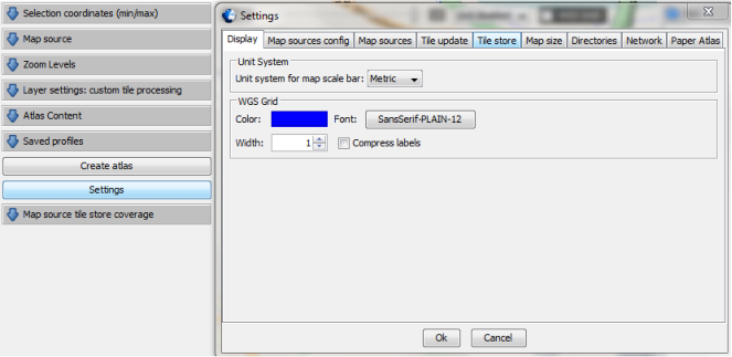
Display
You are able to switch the unit system used in MOBAC between metric (e.g. meters) and
imperial (e.g. feet). Further the appearance of the WGS-grid can be adjusted.
Map sources config
This tab allows you to update the map pack which includes the available map sources.
Moreover you can input login data for premium map sources.
Map sources
You can enable and disable individual map sources. All available maps are displayed and
can be activated or deactivated by using the blue arrows. Even the order in the selection
box can be adjusted.
Tile update
When creating an atlas the data will be downloaded as single tiles of the map. If you use
MOBAC later again and there is already suitable data stored on your hard disk the program
will use it again. A new download is not necessary. However, the stored tiles have an
expiration date after that they will not be used anymore. Use the slider to adjust default,
minimum and maximum expiration time.
Tile store
This tab allows you to enable and disable the local storage of map data. Further it gives you
information about the disk space currently used.
Map size
You can select the maximum size of individual map layers. It can be necessary to adjust this
if your handheld or smartphone application has limitations regarding the map size.
Directories
Let you define the output directory, which is used to store your created atlases.
Network
This tab provides settings regarding your network connection. You can change the number
of parallel network connections for tile downloading. If you increase this number you can
probably speed up the download process. But be careful and check if your internet
connection as well as the map source works with the chosen setting. Further you can limit
the bandwidth and configure HTTP proxy settings. You can also activate a setting that
ignores download errors by default. This is helpful if you create your atlas while you are not
using your computer, because it will not stop the process in case of an error with a single
tile.
Paper Atlas
The last tab allows you to configure the creation of paper atlases. These settings concern
only the atlas formats "Paper Atlas (PDF)" and "Paper Atlas (PNG)" and allow adjusting the
appearance.


 Settings
Configure the settings to fit your needs.
Settings
Configure the settings to fit your needs.


 © Mobile Atlas Creator 2012


 In delivery MOBAC is configured in a way that should fit most operational environments.
However sometimes it is useful or necessary to customize it to your needs. You can do
this in the settings window, which can be opened with the "Settings" button (1) in the left
panel. Inside the windows the configuration opportunities are grouped in tabs (2).
In delivery MOBAC is configured in a way that should fit most operational environments.
However sometimes it is useful or necessary to customize it to your needs. You can do
this in the settings window, which can be opened with the "Settings" button (1) in the left
panel. Inside the windows the configuration opportunities are grouped in tabs (2).
 <Settings Menu>
(1)
(2)
<Settings Menu>
(1)
(2)


Settings
Configure the settings to fit your needs.
© Mobile Atlas Creator 2012
In delivery MOBAC is configured in a way that should fit most operational environments.
However sometimes it is useful or necessary to customize it to your needs. You can do
this in the settings window, which can be opened with the "Settings" button (1) in the left
panel. Inside the windows the configuration opportunities are grouped in tabs (2).
<Settings Menu>
(1)
(2)